It is with mixed emotions that I mark the end of Mayor Bloomberg's time in office. The city's yawning gap between rich and poor has left many, including myself, wanting a new direction, and the result was Bill de Blasio's thumping of centrist Democrats and Republicans alike. But I will give credit where credit is due. Mayor Bloomberg and his transportation commissioner, Janette Sadik-Khan, presided over an unprecedented expansion of transit and bike/ped options in New York. They weren't always well thought out, such as the 7-line extension which primarily served the interests of real estate developers at Hudson Yards, and they weren't always effective (watered down BRT on 34th Street comes to mind), but they did serve to fundamentally reshape New York's transportation landscape. While bike lanes and pedestrian plazas still arouse strong emotions (and the occasional lawsuit), their implementation over the past decade has become increasingly commonplace. Unlike many of the Mayor's policies, these improvements have enriched the lives of New Yorkers rich and poor, and I hope that Mayor de Blasio will continue - and improve upon - them as he takes office. With that in mind, I offer my own take on priorities for Mayor de Blasio and his to-be-appointed DOT and NYPD commissioners.
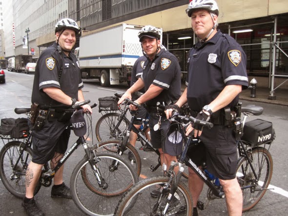 |
| NYPD Bike Patrol / Photo: Streetsblog |
Increase foot and bike patrols by the NYPD. For a city trying to heal itself from more than a decade of stop and frisk, foot and bike patrols have their own value as proven methods to develop trust between police and communities. But from a transit perspective, we should also push for keeping officers out of their cars and on the streets. The NYPD under Ray Kelly seems reluctant to investigate pedestrian injuries and downright intent on harassing and ticketing cyclists. Putting officers in the shoes of those they have failed to help is a powerful tool to help the NYPD develop respect and understanding for cyclists and pedestrians, and it will make officers more aware of the laws they are supposed to enforce.
Pursue SBS-type improvements for non-SBS routes. Obviously this is as much an MTA issue as a city issue, but NYCDOT does have control over bus infrastructure such as lanes and stops. Many of the improvements that have been shown to decrease travel times - offboard fare payment and increased stop spacing - can be implemented relatively quickly and (in well-traveled corridors) cost-effectively. Other improvements, such as bus bulbs and improved shelters with real-time arrival information, are well within the city's control. All of these could help improve the mobility of New Yorkers without requiring significant capital spending.
Expand the city's red light and speed camera programs. New York lags behind many major cities in its enforcement of moving violations by camera. The NYPD has been resistant to change (partly due to the risk of job cuts), but the fact remains that the NYPD issues shockingly few summonses for speeding and other moving violations. As New York moves toward a 20 mph citywide speed limit for residential streets, enforcement will become even more important. I hope that with a change at One Police Plaza and a mayor who has pledged to eliminate traffic fatalities, the new administration will fight to expand the use of cameras citywide.
Increase Citibike's footprint. The bike sharing program has proved very popular in Manhattan and the few areas of Brooklyn where it exists, and current plans have areas such as Cobble Hill and Park Slope slated for expansion. Given the Mayor's focus on inequality, I hope that he will also push for expansion into Red Hook, Bed Stuy, Bushwick, Sunset Park, and other less affluent areas with relatively good access to the city's wider bike network.
Couple development and transit. Massive new developments in Williamsburg, Greenpoint and the Astoria waterfront have the potential to strain limited transit resources in their respective areas. As a mayor who will seek to dramatically expand the city's affordable housing options, Mayor de Blasio cannot follow that blueprint. He and his planning team should consider proximity to transit and area capacity when deciding where to upzone - focusing the densest development near existing transit hubs (Downtown Brooklyn, Long Island City, Broadway Junction) rather than adding development in areas where transit would be strained or new residents would be forced to drive.
And finally...
Cut parking minimums citywide. The Mayor's goal of increasing affordable housing will never get off the ground if developers are constrained by the added costs of building unnecessary parking. Less than a third of New Yorkers commute by car, so Mayor de Blasio would be well served to enhance transit access, rather than give in to outdated planning ideas.
None of these ideas outlined are as costly or as ambitious as some of Mayor Bloomberg's larger plans, but they can nonetheless serve to enhance pedestrian and cyclist safety, give more transit options to all New Yorkers and help the new mayor achieve his goal of drastically increasing affordable housing options.

